![](/images/other/stat-length.png)
![Tour Wandern La Chapelle-en-Valgaudémar - Valgo 2 - J6 : refuge du Pigeonnier - Photo](https://media.geolcdn.com/t/1900/400/c6689721-e653-43be-95d0-5a3d660e8f8a.jpg&format=pjpeg&maxdim=2)
Valgo 2 - J6 : refuge du Pigeonnier
ETMU5496
Benutzer
![Länge](/images/other/stat-length.png)
![Maximale Höhe](https://static1.geolcdn.com/siteimages/upload/files/1508320355ic_sort_altitude_max_24dp.png)
![Positive Höhendifferenz](https://static1.geolcdn.com/siteimages/upload/files/1508320355ic_sort_den_pos_24dp.png)
![Km-Effort](/images/other/stat-length.png)
![Min. Höhe](https://static1.geolcdn.com/siteimages/upload/files/1508320355ic_sort_altitude_min_24dp.png)
![Negative Höhendifferenz](https://static1.geolcdn.com/siteimages/upload/files/1508320355ic_sort_den_neg_24dp.png)
![Boucle](https://static1.geolcdn.com/siteimages/upload/files/16400158638029165_repeat_loop_refresh_sync_direction_icon.png)
![Wandern](https://static1.geolcdn.com/sitytour/trail-icons/101.png)
4h15
Schwierigkeit : Schwierig
![Scannen Sie diesen QR-Code, um die Tour in der SityTrail-Anwendung zu öffnen](https://capi.geolives.com/qq0zvz2zws4bq2lad0pu/sitytour/trails/2847435/qr.png?size=200)
Kostenlosegpshiking-Anwendung
Über SityTrail
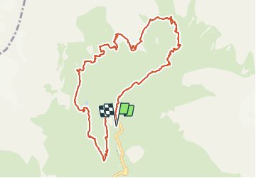
Tour Wandern von 13,4 km verfügbar auf Provence-Alpes-Côte d'Azur, Hochalpen, La Chapelle-en-Valgaudémar. Diese Tour wird von ETMU5496 vorgeschlagen.
Beschreibung
Depuis le chalet de Gioberney, ascension dans ce magnifique cirque glaciaire pour atteindre le refuge du pigeonnier en passant par l'abri du Vivaccier.
Redescendre ensuite vers la vallée pour remonter ensuite et atteindre le lac bleu.
Retour ensuite vers le chalet de Gioberney
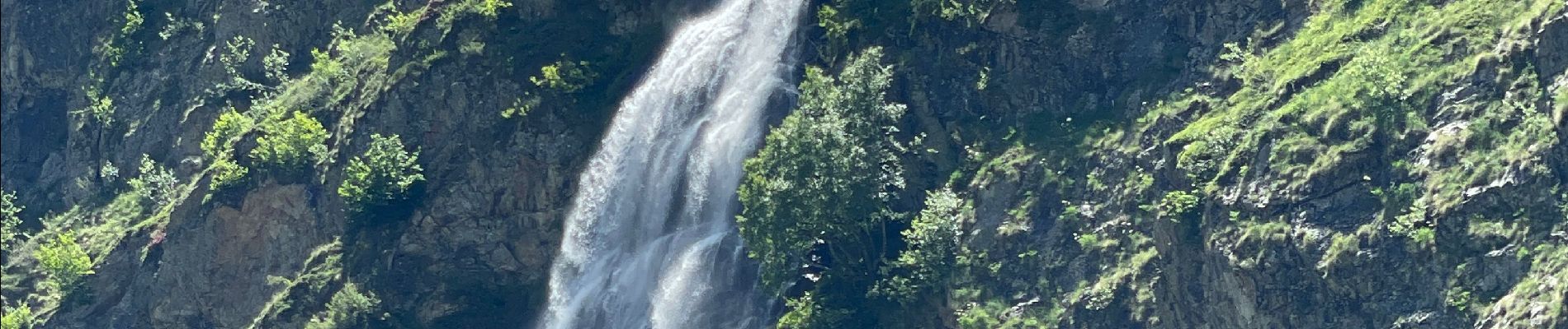
Ort
Kommentare
Touren in der Umgebung
![Wandern Wandern](https://static1.geolcdn.com/sitytour/trail-icons/101.png)
Wandern
![](/images/other/stat-length.png)
![](https://static1.geolcdn.com/siteimages/upload/files/16400158638029165_repeat_loop_refresh_sync_direction_icon.png)
![Tour Wandern La Chapelle-en-Valgaudémar - Tour du Vieux Chaillol 2/5 - Du Gîte Le Casset au Refuge de Vallonpierre - Photo](https://media.geolcdn.com/t/375/260/ext.jpg?maxdim=2&url=https%3A%2F%2Fservices.sitytrail.com%2FGeolivesWS%2FDownloadMedia.ashx%3FTrailID%3D110181%26Media%3D5395_2.jpg)
![Wandern Wandern](https://static1.geolcdn.com/sitytour/trail-icons/101.png)
Wandern
![](/images/other/stat-length.png)
![](https://static1.geolcdn.com/siteimages/upload/files/16400158638029165_repeat_loop_refresh_sync_direction_icon.png)
![Tour Zu Fuß La Chapelle-en-Valgaudémar - Refuge du Pigeonnier - Photo](https://media.geolcdn.com/t/375/260/ce7c5daf-99aa-48e8-b5ea-75a2997b18fd.jpg&format=jpg&maxdim=2)
![Zu Fuß Zu Fuß](https://static1.geolcdn.com/sitytour/trail-icons/100.png)
Zu Fuß
![](/images/other/stat-length.png)
![](https://static1.geolcdn.com/siteimages/upload/files/16400158638029165_repeat_loop_refresh_sync_direction_icon.png)
![Zu Fuß Zu Fuß](https://static1.geolcdn.com/sitytour/trail-icons/100.png)
Zu Fuß
![](/images/other/stat-length.png)
![](https://static1.geolcdn.com/siteimages/upload/files/16400158638029165_repeat_loop_refresh_sync_direction_icon.png)
![Zu Fuß Zu Fuß](https://static1.geolcdn.com/sitytour/trail-icons/100.png)
Zu Fuß
![](/images/other/stat-length.png)
![](https://static1.geolcdn.com/siteimages/upload/files/16400158638029165_repeat_loop_refresh_sync_direction_icon.png)
![Tour Wandern La Chapelle-en-Valgaudémar - Valgaudemar - Gioberney Lac du Lauzon - 7.3km 490m 2h45 - 2018 06 27 - public - Photo](https://media.geolcdn.com/t/375/260/ext.jpg?maxdim=2&url=https%3A%2F%2Fservices.sitytrail.com%2FGeolivesWS%2FDownloadMedia.ashx%3FTrailID%3D999345%26Media%3Dfix__20180627142404.jpg)
![Wandern Wandern](https://static1.geolcdn.com/sitytour/trail-icons/101.png)
Wandern
![](/images/other/stat-length.png)
![](https://static1.geolcdn.com/siteimages/upload/files/16400158638029165_repeat_loop_refresh_sync_direction_icon.png)
![Tour Wandern La Chapelle-en-Valgaudémar - Valgaudemar - Rif du Sap Le Clot - 6km 190m 1h45 - 2018 07 04 - public - Photo](https://media.geolcdn.com/t/375/260/ext.jpg?maxdim=2&url=https%3A%2F%2Fservices.sitytrail.com%2FGeolivesWS%2FDownloadMedia.ashx%3FTrailID%3D998794%26Media%3Dfix__20180704131615.jpg)
![Wandern Wandern](https://static1.geolcdn.com/sitytour/trail-icons/101.png)
Wandern
![](/images/other/stat-length.png)
![](https://static1.geolcdn.com/siteimages/upload/files/16400158638029165_repeat_loop_refresh_sync_direction_icon.png)
![Tour Wandern La Chapelle-en-Valgaudémar - Valgaudemar - Gioberney Refuge de Vallonpierre - 16km 850m 5h35 - 2018 07 03 - public - Photo](https://media.geolcdn.com/t/375/260/b31b91c8-a8b7-444d-8b10-22f70d1d8991.jpg&format=jpg&maxdim=2)
![Wandern Wandern](https://static1.geolcdn.com/sitytour/trail-icons/101.png)
Wandern
![](/images/other/stat-length.png)
![](https://static1.geolcdn.com/siteimages/upload/files/16400158638029165_repeat_loop_refresh_sync_direction_icon.png)
![Tour Wandern La Chapelle-en-Valgaudémar - PARC NATIONAL DES ECRINS: REFUGE DU PIGEONNIER - Photo](https://media.geolcdn.com/t/375/260/63f96214-74ba-423a-b110-db305c3e34c6.jpg&format=jpg&maxdim=2)
![Wandern Wandern](https://static1.geolcdn.com/sitytour/trail-icons/101.png)
Wandern
![](/images/other/stat-length.png)
![](https://static1.geolcdn.com/siteimages/upload/files/16400158638029165_repeat_loop_refresh_sync_direction_icon.png)